| ||||||||||||||||||||||||||||||||||||||||||||


Press Comments
Lancaster Guardian, 22.03.2002
Between a rock and an art place
by James Reader
Turner and Tolkien knew it, now an exciting new project promises to record
the richness and unique variety of the Forest of Bowland and the Lune Valley
so that more people understand and appreciate it.
Two weeks ago the Lancaster Guardian revealed how a myth carved on to Viking
stones in Halton churchyard during the Dark Ages was the inspiration for Tolkien´s
Lord of the Rings.
For some areas this would be enough in itself as a legitimate claim to fame.
Not so in the Lune Valley and Forest of Bowland. Here the stones are just one
of scores of unique features of the landscape left by successive generations
since 10,000 BC, when nomadic hunters first settled in the area.
Sets of earth mounds that once formed the border with Scotland and a whole prehistoric
community buried under vegetation can both be found within a few miles of Lancaster.
But despite such a wealth of history the area is often overlooked in favour
of the Dales and the Lake District.
Its cultural landscape is under-appreciated both publicly and by archaeologists
and as such its development is less controlled than in other areas.
But all that could be about to change.
The Lune Valley and Bowland have been selected from competition from other
areas across the country to represent England in a new European-wide project
which promotes understanding the history and culture of the landscape.
"What we are trying to do with this project is incorporate an academic
overview with what people think who actually live or work in these areas,"
said John Darlington, project manager on the European Pathways to the Cultural
Landscape.
It is an area under threat of change and needs a better-informed and more effective
approach to its management.
After all, how can you protect what you don´t know is there?
"In terms of Bowland and the Lune Valley the planning rules and regulations
are pretty stringent," said John. "But with agriculture we are going
to see the landscape changing quite significantly. "The reason it was successful
and the reason it was selected is because I guess it is undiscovered."
" Here you have got an historic landscape which people do not necessarily
understand and appreciate. What we are trying to do is to get people to understand
it better."
The project uses map-based techniques to improve the understand-ing of the historic
and archeological dimension of the present-day landscape.
But it is not dry and academic. Engaging local communities and asking people
what they think is important is a key component.
Myths, folklore and how people feel generally about the area can all change
the priority given to sites and landscapes as well as fleshing out the bones
of academic research.
"It is trying to link us in the present to folk right back in the past,"
said John.
The Forest of Bowland covers over 800 square kilometres of upland and is a western
spur of the Central Pennines. It received statutory recognition in 1964 as an
Area of Outstanding Natural Beauty, a designation which increasingly acknowledges
the human contribution towards landscape.
The Lune Valley lies on its northern fringes.
They both have distinctive cultural landscapes, but resources from both moorland
and valley was required to sustain historic communities.
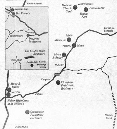
The main archeological and historical attributes recognised so far include:
- Prehistoric spiritual and burial sites on the upland moors and valley sides
- Roman military forts and roads and place-names of early ´Celtic´ and Scandinavian origin
- Water-powered industrial sites, first for grain, later adapted for the cotton industry
- Parkland landscapes focused upon high-status houses and a highly distinctive stone architectural tradition of the 16th and 18th Century
"What this tries to do," he said, "is map the kind of landscapes
that still exist today."
In 1999 English Heritage and Lancashire County Council were invited to contribute
towards a cross-European project bid to the European Union´s new Culture
2000 programme.
The Bowland-Lune national project is a three-year project jointly funded by
the EU, Lancashire County Council and English Heritage. Eventually 12 separate
national projects in 10 countries will link together information and ideas on
the promotion and management of cultural landscape.
It serves a variety of uses. It can be protect the character of the countryside
character and it is part of a wider framework of national archeological programmes.
It will also have a bearing on the Local Plan.
So watch out the next time you walk over a lump in a field - it might just have
international importance.
FIVE FACTS YOU (PROBABLY) DIDN´T KNOW ABOUT THE FOREST OF BOWLAND AND THE LUNE VALLEY
1. It is a myth that the country was once covered in forests. There are no more trees in the tune Valley and the Forest of Bowland than there were in the late Bronze Age.
2. So why is it called the Forest of Bowland? It is a legal status used as a stealth tax. Those who hunted or farmed on what was once a royal ´forest´ would be charged.
3. In the middle ages the biggest cattle ranches in England, called vaccaries, were based in the Lune Valley.
4. More than likely Bowland harbours the ´Pompei of Northern England´. Hidden underneath the peat and vegetation lies archeological evidence of a whole community.
5. In the heady-days following the Norman Conquest the River Lune formed the border with Scotland. The motte and bailey forts that guarded the disputed border are still dotted up and down the river.
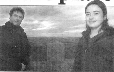
John Darlington and Jo Clark at the top of the Jubilee Tower overlooking Quernmore valley at Forests of Bowland
photo: Richard Lee
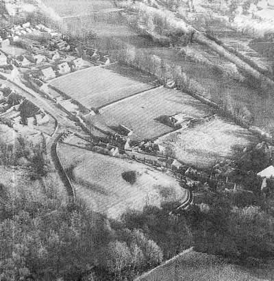
The castle in Halton which at one time might have guarded England´s border with Scottland
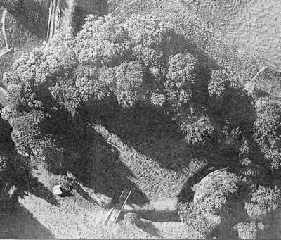
An aerial photograph of the mott and bailey Castle Stede built in about 1100.
|
|
|
|