| ||||||||||||||||||||||||||||||||||||||||||||||


Rakovice: Late Iron Age rectangular enclosure
After years of investigations and discussions on central European La Tene period rectangular enclosures, surprisingly little is known about their function. Besides the conservative view of enclosures solely as ritual places, several other possible functions are accepted (1) use for ceremonial meetings, which corresponds with historical sources, (2) central places with diversified functions including storage and redistribution (3) a specific type of settlement unit - a homestead and (4) the seat of a rural elite household. The La Tene rectangular enclosures need not always have served one and the same function but could have gradually evolved and fulfilled different roles throughout time.
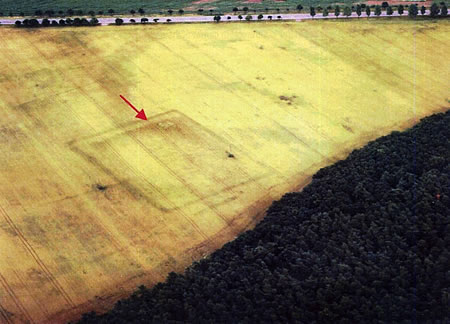
M Gojda discovered the site at Rakovice from the air, during a photographic survey of the landscape around the Boudy hillfort. The flight was undertaken as part of the PCL project. An aerial photograph of the site showed the dark crop mark of a rectangular enclosure ditch with a lighter crop mark behind the ditch, within the enclosure, which was considered to be an internal bank being cut and reduced by the plough. The morphology of the enclosure suggested that it could be of a type commonly known as "Viereckschanzen", which are datable to the La Tene period of the European Iron Age. However, historically it was also thought that troops had been active in the area at the time of the thirty years war in the 17th century and that the enclosure could be a camp connected with their military activities.
The site is located approximately 455m above sea level on the upper east facing slopes of the valley of the River Skalice. The dimensions of the rectangular enclosure are 115x 80m.
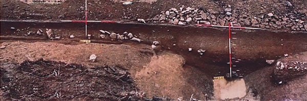
A small evaluative excavation was undertaken in October 2001, The questions posed concerned the form, function and date of the enclosure. Excavation Trench 1 cut the enclosure rampart bank, with its associated erosion deposits, and the enclosure ditch in the central area of the trench crossing from north to south. Excavation Trench 2 was put in the southwestern corner of the area.
The excavation revealed, that the enclosure ditch was really built within the La Tene period. A well defined period of re-use is dated to sometime in the 17th century and a less certain period of re-use is suggested for the late 13th century. The internal bank of the enclosure was probably reverted with stone to form a box rampart. This would be a new form of structure associated with this type of monument. In this context it is interesting to note that the side of the enclosure through which the excavation trench was cut, was the side most visible on the aerial photograph and this could possibly mean that the stone box rampart was only built along this one side, the eastern. The stonework would have protected the bank core from being totally ploughed out, as the other sides may have been if they were not similarly protected. This is also the side that faces out to the valley beyond and would therefore have been the most visible and impressive. Such a single sided structure of stone is in accordance with the growing feeling that some of these enclosures are concerned with power and display rather than actual military defense.
|
|
|
|